Monday, October 15, 2012

The Parks System


Milwaukee's interwoven green space is the lasting legacy of socialist control and influence.  The county, having secured 1,977 acres of parkland by 1930, looked to urban planning to translate the social and environmental goals of the Progressive Era into a program of action sensitive to the paramount concerns of human health and leisure.  The protection and restoration of natural drainage patterns were seen as vital to public health; forested areas adjacent to streams were valued for runoff absorption, sustaining groundwater levels and ensuring an even stream flow (Erickson, p. 111).  With the county's purchase of first lands in 1890, protecting the "lungs of the city" incidentally set the stage for wetland protection, flood control, stream bank restoration, sanitation, environmental education.


And (if you've ever visited Estabrook Park) frolf.  

The Oak Leaf Trail

The Oak Leaf trail is Milwaukee County Parks', magnum opus.  Not straying far from Charles B. Whitnall's initial design, the actualization of the approximately 100 mi trail loosely follows the Milwaukee River, weaving its way through the heart of Milwaukee, its suburbs, and the Lakefront.  A few of the "happening" recreations sites along the trail double as sampling sites within this field study. 


Kletzsch>>>  
Estabrook>>>  


Refs--

Erickson, Donna L. MetroGreen: Connecting Open Space in North American Cities. Washington: Island, 2006. Print.


Images: 
[1] http://www.boernerbotanicalgardens.org/support/v6a.jpg
[2] http://ars.els-cdn.com/content/image/1-s2.0-S0169204603001609-gr3.jpg
[3] http://www.planetmobility.com/store/scooters/shoprider/sprinter-2-seater/889-4DXD.jpg


The Milwaukee Watershed

A Brief History
Lifted and 'smithed from this DNR report.


The Milwaukee River Basin
[1]

The Milwaukee River Basin ranges from a height of 1360 ft above sea level in the Northern Unit of the Kettle Moraine State Forest to 580 ft at the Milwaukee Harbor.  Formed by glacial deposits superimposed on underlying bedrock, the surface of the basin slopes downward from the north and west to the south and east.  The Milwaukee River from start to finish occupies two thirds of the basin area (584 sq mi), further dividing the watershed into the Milwaukee River North, Milwaukee River East-West, and Milwaukee River South. About 18% of the land area of the basin is covered by urban uses, while the remainder is considered rural.  Agriculture is still dominant in the northern half of the basin.


The Milwaukee River

[2]Headwaters
The Milwaukee River mainstem is the longest river in this watershed (53 miles), beginning in wetlands in Fond du Lac County, flowing in a southeasterly direction until meeting the North Branch Milwaukee River near Waubeka. Upstream of Kewaskum, wetland drainage, river straightening, especially the smaller headwaters streams, dams and agricultural runoff are the major factors keeping the rivers from fully meeting their potential.  Downstream of Kewaskum, the river is increasingly affected by urban land uses and five major dams, leading to degraded habitat and water quality from nutrient and sediment inputs.


Middle and Lower Reaches
The Milwaukee River South Watershed covers about 168 sq mi and is located in portions of Ozaukee and Milwaukee Counties.  The Milwaukee River mainstem enters the watershed west of the Village of Fredonia and flows for about 48 miles before entering the Milwaukee Harbor. Land cover in the watershed is a mix of rural and urban uses.  Overall, the watershed is about 33 % urban, with agriculture (25%), grasslands (21%), forests (12%) and wetlands (6%) making up the rest of the major land cover types.  Fourteen cities and villages are found in this watershed. As with the other watersheds in the basin, the streams in the Milwaukee River South Watershed exhibit a wide range of quality.  Over 35 stream miles within the Milwaukee South Watershed are listed as areas of concern*.  The Milwaukee Estuary area of concern encompasses the Milwaukee Harbor, the Milwaukee River downstream from the abandoned North Avenue Dam, the Menomonee River downstream from 25th street and the Kinnickinnic River downstream from Chase Avenue.  

*The International Joint Commission (IJC) and U.S. EPA designated the Milwaukee Estuary in 1987 through the Great Lakes Water Quality Agreement as one of 43 Great Lakes Areas of Concern.  These areas are usually industrial in nature, with a history of pollution.  In the Milwaukee Estuary, sediments contaminated with polycyclic aromatic hydrocarbons (PAHs), polychlorinated biphenyls (PCBs) and heavy metals are linked to degraded water quality, impaired fish and wildlife populations, and restrictions on dredging.  


Some other demerits...

  • About 12 % of the total stream miles in the basin do not meet water quality standards on a consistent basis.  With few exceptions, the lower quality streams are located in the most densely populated areas in the basin.  Many of these streams were modified by straightening, enclosure or concrete lining to move water off the land and more quickly downstream.  
  • Nearly 15% of all perennial stream miles in this watershed are significantly modified to the extent they have limited ability to sustain diverse biological communities.  Many of these streams were straightened, enclosed or lined with concrete to facilitate water movement downstream to alleviate flooding concerns.  This method to control flooding, while popular 35 years ago is now considered somewhat ineffective.  From a water quality and biological standpoint this type of river modification causes wide fluctuations in water levels over short periods of time, increases channel scour, and provides little to no habitat for aquatic life.  Establishing a meandering stream helps create more diverse habitat for biological activities.  The Milwaukee Metropolitan Sewerage District (MMSD) is implementing major flood water storage and where possible and is supportive of river restoration activities.
  • Most of the tributary streams in the Milwaukee County portion of this watershed are only capable of supporting populations of more pollution tolerant fish species like common carp.  Non-native species such as rainbow trout, coho, and chinook salmon migrate from Lake Michigan into the Milwaukee River during their seasonal spawning runs.  Habitat and water quality are not sufficient to allow for successful reproduction of these species in the rivers where they spawn so annual stocking of these species is needed to maintain recreational fishing opportunities.  


The Parks System >>>


Refs--


Wisconsin. Department of Natural Resources. N.p., n.d. Web. 10 July 2012. <http://dnr.wi.gov/water/basin/milw/milwaukee_801.pdf>.

Images:
[1] http://watershedmke.files.wordpress.com/2010/07/greater_milwaukee_watersheds.jpg
[2] http://www.swwtwater.org/home/images/MilwaukeeWatersheds%20Map.jpg

Friday, October 12, 2012

Interpreting Water Quality

Water Quality Parameters
Characterizing a body of water
[1]
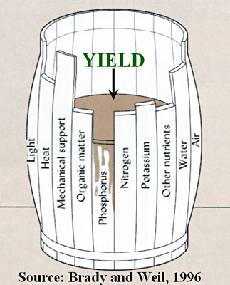
So, what are we measuring within these transects and how is the data comparable? Habitat Assessment [Expanded] lists typical evaluative parameters used to obtain current vitals of a river and gain insight on contemporaneous instream dynamics. The template considers abiotic factors as well as biotic factors, that act upon a stream community.  Physicochemical variables can be directly evaluated by measuring the concentration of dissolve and suspended substances in the water that may come from atmosphere, entering the system via precipitation or are picked up from soil, vegetation, and other sources via runoff (Murdoch).  Biotic sampling can be implemented to survey the local stream community, quantify biodiversity, and (by indexing the presence and abundance of bioindicators) can similarly evidence less tangible parameters. Most water quality parameters are considered limiting factors, as the proportional presence and concentration of these parameters can alter aspects of water chemistry, having a direct effect on population "yield" and constitution (illustrated in Brady and Wiel's classic barrel model, pictured above).


Limiting Factors
A limiting factor is an aspect of the environment that limits population distribution (and per our interests, jointly affects trophic composition).  These can be physical/spatial limitations (mechanical supports/substrate, stream current/velocity, temperature, light, and heat), chemical constituents (phosphorous, nitrogen, potassium, and other nutrients), or biotic interactions (competition, predation, and herbivory). 

Comparing BMIs:
Pollution Tolerance, Taxa richness, and Trophic Guild Composition

Benthic Macroinvertebrates and Pollution Tolerance
Organic pollution can manifest as excess nutrients or sediments, causing low dissolved oxygen conditions. This is especially problematic in areas of high sedimentation and impoundment. In general, mayflies, stoneflies, and caddisflies have the lowest tolerance to pollution (existing in well oxygenated areas and areas with low sedimentation), while midges aquatic worms, leeches, and blackflies, have the highest (existing within sediment and areas of high embeddedness).  Beetles, craneflies and crustaceans tend to be in the "somewhat tolerant" (Murdoch, p.135).

Be the ascription pollution tolerant or pollution intolerant, we are really discussing oxygen as a limiting factor. Benthic macroinvertebrates (BMIs) have varying oxygen demands, requiring a specific current velocity for respiration and distribution, and display a substrate preference relative to their metabolic needs. Though someBMIs are habitat generalists, others predictably appear within a narrow set of parameters.    

A Biotic Index
Generalizations about the consistent life history and behavioral patterns of BMIs can be translated into a biotic index. A biotic index, is a comparative metric used to evaluate stream community composition and assess water quality. This streamlined platform requires the cataloging and indexing of local instream BMIs. Each order (or family, depending on evaluative technique) is assigned a pollution tolerance value (scale of 1-10). Their the proportional quantification (relative to sample size) is then entered into a formula that takes into account these pollution tolerance values (and collection method) to calculate the overall water pollution tolerance of the community, and conjunctively describe current water quality conditions.


Choosing an Index
Not just any index will do. The science behind the scales is a little more sensitive than I care to divulge, but each index is customized to a particular region... An intermittent creek in the the Texas Hill Country would fair poorly on a scale tailored for perennial streams in the western Great Lakes region; clearly an inappropriate metric in this scenario.

The scale chosen for this field study, is Paul's Biotic Index (PBI) pictured below.

Using a Biotic Index
[2]

Referencing the scale is pretty self explanatory (uh, see above).  But getting final, representative figures worth comparing is a whole other matter.

As with any technique, representativeness, accuracy, and precision will come with consistency and time. Biotic sampling, (if processed correctly, and consistently) is a sound water quality assessment tool and extremely useful for comparative studies. Admittedly, the collecting and cataloging are the most tedious parts of the process, but using a biotic index streamlines data and reduces error.  

The approach does have have some short comings. Because of idiosyncrasies in collection method, selective biases, and the relativity values, data is difficult to share and compare outside of its own design parameters. Otherwise, the raw information is easy to process and format for any number of existent scales (FBI, HBI, R.W. Bode Scale, etc). 

Other Intel
Further extrapolations can be made from the same raw data collected for a biotic index.


Biodiversity: Taxa richness directly correlates with the total number of taxa. The greater the taxa richness, the greater the diversity of BMIs.

Trophic Composition: Each specimen group can be further classified by a shared feeding strategy (this requires background knowledge of an organism's life history and habitat/substrate preference). Assessing their proportional relationships of these functional feeding groups can describe the trophic dynamics of the sampled community.


Infographics!>>>


Refs--


Engevold, Paul. PBI and Trophic Structure. N.p.: n.p., n.d. Print.

Engevold, Paul. Stream Comparisons - The Parts Equal the Whole. N.p.: n.p., n.d. Print.
Murdoch, Tom, Martha Cheo, and Kate O'Laughlin. The Streamkeeper's Field Guide: Watershed Inventory and Stream Monitoring Methods. Everett, WA: Adopt-a-Stream Foundation, 1996. Print.

Images:
[1]
[2]


Thursday, October 11, 2012

Functional Feeding Groups

Troph Tropes:

Trophic levels are used to classify organisms by their feeding habits.  Ya know, (taxonomically speaking) ya gotcha auto/heterotroph bisection; then ya got yer herbivores, carnivores, and detritivores- Basic food-web stuffs.  In this field study, specimens were were indexed by family and classified by their tropic guilds.


Trophic guilds take this notion of feeding habits a step further, suggesting a prevailing link between morphological and behavioral adaptations that maximize the effectiveness of a preferred feeding strategy (Alexander, p.255), as illustrated in this cool drawing of various nematodes and their mouth parts. 


[2]
Figure 2. Nematodes can be classified into different feeding groups based on the structure of their mouthparts. (a) bacterial feeder, (b) fungal feeder, (c) plant feeder, (d) predator, (e) omnivore. Figure credit: Ed Zaborski, University of Illinois 
[3]
Because each feeder supposedly has a concomitant feeding strategy, they can therefore be order into groups. Hence! Functional Feeding Groups.


So, even though the guild ascription ostensibly privileges specialization, you can see in the legend pulled from this study's data, most benthic macroinvertebrates (BMIs) are generalists. 

*To better compare this information with the predictions made by the River Continuum, only organisms strictly classified as shredders, collectors, predators, and/or grazers were counted.  Below are each groups' characteristics and a few predictions.  [There's also a spiffy chart I yanked for quick reference below the RCC diagram.]


Functional Feeding Groups:


Shredders munch on decaying organic matter (leaves, twigs, etc.)  This coarse particulate organic mater (or CPOM) is directly correlated with canopy cover and riparian vegetation.  SO.  There should be a high percentage of shredders in headwaters (or a low order stream).


Scrapers and grazers rasp algae from the substrate.  Algae needs sunlight to propagate.  SO.  There should  be a fair percentage of scrapers and grazers in the middle reaches of a river (or a mid order stream) where there is less canopy cover.


Collectors have morphological and behavioral adaptations best suited to filter, snag, and catch fine particulate organic matter (or FPOM)-- material further broken down or generated by shredders, scrapers, and grazers, such as fine leaf litter, bacteria, and feces.  These guys are found in all stream reaches, but their populations tend to increase in habitats not suitable for shredders and scrapers.  (*Consider the paramount limiting factors, i.e. the substrate, oxygen demand...)


Predators feed on other organisms.  They have morphological and behavioral adaptations suited for capturing prey.  Predators are similarly found in all habitat types, but their populations tend to be small relative to other feeding groups.  

The River Continuum and 
Functional Feeding Groups
[4]
[5]
*To better compare this information with the predictions made by the River Continuum, only organisms strictly classified as shredders, collectors, predator, and/or grazers were counted.


Refs--

Alexander, David, and Rhodes W. Fairbridge. Encyclopedia of Environmental Science. Dordrecht: Kluwer Academic, 1999. Print.
Engevold, Paul. PBI and Trophic Structure. N.p.: n.p., n.d. Print.
Engevold, Paul. Stream Comparisons - The Parts Equal the Whole. N.p.: n.p., n.d. Print.
Vannote, Robin L., G. Wayne Minshall, Kenneth W. Cummins, James R. Sedell, and Colbert E. Cushing. "The River Continuum Concept." Canadian Journal of Fisheries and Aquatic Sciences 37.1 (1980): 130-37. Print.

Images
[1] Personal Painting
[3] Vector Legend, Personal Illustration
[4] Vector Stream with RCC Projections, Personal Illustration
[5] Chart reproduced from, PBI and Trophic Structure,  Engevold, Paul


The River Continuum Concept


The River Continuum Concept is a testable hypothesis proposed by Vannote et al 1980 that suggests consistent, observable patterns of community structure and function along the length of a natural, unperturbed river.

Stream Course {Rehashed from Anatomy of a River}
A river's total expanse (or stream course) can be transected across its longitudinal dimensions. These sections and their characteristics reflect their chronological designation. The chronology is tied to the unidirectional flow of a river, begging at its source in the upper course, passing through the middle course, and finally terminating in the lower course. These stream reaches are similarly personified, the upper reaches being described as youthful, the middle reaches, mature, and the lower reaches, old. The parsimonious illustration below lists characteristics and features respective to their course.


Attributes of Stream Course Within The RCC Model:

[2]
Head Waters:
Stream order [1-3]
High [CPOM]
Processing: Heterotrophic
Production/Consumption (Respiration)
P/R<1


Middle Reaches:Stream Order [4-6]
[CPOM] and [FPOM]
Processing: Autotrophic
Production/Consumption (Respiration)
P/R>1

Lower Reaches:
Stream Order [7-10]
[FPOM]
Processing: Heterotrophic
Production/Consumption (Respiration)
P/R<1


Other Projections
Dams and the RCC>>>


Refs--
Vannote, Robin L., G. Wayne Minshall, Kenneth W. Cummins, James R. Sedell, and Colbert E. Cushing. "The River Continuum Concept." Canadian Journal of Fisheries and Aquatic Sciences 37.1 (1980): 130-37. Print.


Images:
[1] http://worldbuildingschool.com/files/2012/08/RiverCourse.jpg
[2] Vector Graphic of Stream, Personal Illustration

Lab Methodology

Project Design Recap
To paraphrase the objectives laid out in the Project Design, my intentions are to elucidate how dams impact the ‘normal’ paradigm of a stream and its community. (Ahem. The Ecological Effects of Damming.)

The data collected will be used to quantify and compare:
>Water Quality (Organic Pollution, Physicochemical Parameters, Biotic Interactions)
>Trophic Guild Composition (Functional Feeding Groups)
>Biodiversity (Taxa Richness)
along longitudinal dimension of a the river, as well as against the theoretical projections made by The River Continuum Concept.

Field Work: The Gathering, outlined the number of replicates and habitat locales:

3 Sites [K,E,H]

3 Replicates per habitat [K, E(AboveBelow) + H]

Count approximately 100 specimens per habitat

____________________
15 samples

15 samples translates to 5 habitat assessments and 15 jars that need processing.  

Indexing and Analysis
There's no real magic to it.
Processing the samples for comparison entails dumping the critters out on a sorting tray and indexing them.  To quantify the sample, the specimens are organized by order and or (to better account for functional feeding groups) family, then assigned a biotic value based on the order or family's pollution tolerance (provided by your chosen biotic index). 

Then you do a little math to get your official biotic value and BAM!  Infographics.

But if I might back track just a bit, I'd like to take a moment to review the role and use of a biotic index.

Biotic Indices
As mentioned in Interpreting Water Quality, a biotic index is a scale used in water quality assessment.  Legitimate biologists have assigned pollution tolerance values to different benthic macroinvertebrates (BMIs) families based on their tolerance to organic pollution. The values are on a scale from 1 (least tolerant) to 10 (most tolerant). Organic pollution depresses oxygen levels; oxygen levels delimit a biotic community; ergo, robust water quality assessment tool. 

** Of course, not just any index will do. The science behind the scales is a little more sensitive than I care to divulge, but each index is customized to a particular region...  An intermittent creek in the The Texas Hill country would fair poorly on a scale tailored for perennial streams in western Great Lakes region; clearly an inappropriate metric in this scenario.

Aaaaaanyway. Given our locale, there are several viable biotic indices to choose from... [R.W. Bode scale, Hilsenhoff's Biotic Index (HBI) 1987, etc.]

For this study, referenced.   I referenced a Paul's Biotic Index (PBI), a hybrid of several existent scales. (See Below) 


And lastly another disclaimer!

*Certain sampling methods do significantly affect the taxa collected (Ahem. That's what makes the method semi-qualitative). My mobility in the field was somewhat limited (especially in deep water situations), but I did my best to sample from a variety of microhabitats to best represent the transects.

Some Digestible Formats
Habitat Assessments >>>
Habitat Photos and Biotic Values by site:  [K...] [E...] [H...]
The Data in fine Infographic form>>> 


Refs--


Engevold, Paul. PBI and Trophic Structure. N.p.: n.p., n.d. Print.
Engevold, Paul. Stream Comparisons - The Parts Equal the Whole. N.p.: n.p., n.d. Print.

     "Citizen Stream Monitoring - Data Sheets." Citizen Stream Monitoring - Data Sheets. N.p., n.d. Web. 11 Oct. 2012. <http://watermonitoring.uwex.edu/wav/monitoring/sheets.html>.
     Lenz, Bernard N., and Michael A. Miller. Comparison of Aquatic Macroinvertebrate Samples Collected Using Different Field Methods. [Reston, Va]: U.S. Dept. of the Interior, U.S. Geological Survey, 1996. Print.
     Murdoch, Tom, Martha Cheo, and Kate O'Laughlin. The Streamkeeper's Field Guide: Watershed Inventory and Stream Monitoring Methods. Everett, WA: Adopt-a-Stream Foundation, 1996. Print.


Images:
[1] Image generated using Google Maps
[3] Chart replicated from PBI and Trophic StructureEngevold, Paul

Kletzsch

Located in the city of Glendale, Kletzsch Park formed in 1918 with the acquisition of the 35 acre Blatz farm and was later named after Alvin P. Kletzsch, a member of the Park Commission (1907-1941).  Archaeological studies done in the early 1930's indicated that a portion of the park once contained an Native American camp and burial ground. The low-head dam was constructed as part of the Civilian Conservation Corps project.  Built of reinforced concrete, the design was intended increase discharge capacity without widening the river.  The drop gives the appearance of a natural waterfall.  


The Parks System>>>


June 10, 2012
Habitat Above [Impoundment]:
Lentic
CollectionTime: 12-2 pm
Specimen Count: 104
BMI Rating: 5.1


Habitat Below [Impoundment]:
Lotic
Collection Time: 5-6 pm
Specimen Total: 141
BMI Rating: 4.1


Refs--
"Kletzsch Park History." Kletzsch Park History. N.p., n.d. Web. 16 Oct. 2012. <http://www.kletzschfriends.org/KletzschHistory/tabid/1118/Default.aspx>.


Personal Photos:
[1] Image generate using Google Maps

[2-12] Personal Photography